Geoselect 3.0.0
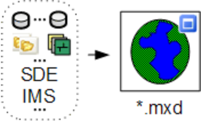
Geoselect is the ArcGIS 9.x extension that collects data sources of the current active project to one folder in the specified format, adapts the project (mxd) to the new data, checks of duplicates, projects all layers to uniform coordinate ...
Last update
23 Jul. 2010
Licence
Free to try |
$95.00
OS Support
Windows
Downloads
Total: 557 | Last week: 5
Ranking
#210 in
Misc
Publisher
Gis Center
Screenshots of Geoselect
Geoselect Publisher's Description
Geoselect is the ArcGIS 9.x extension that collects data sources of the current active project to one folder in the specified format, adapts the project (mxd) to the new data, checks of duplicates, projects all layers to uniform coordinate system of the project (re-project) and preserves relative paths.
Functionality:
Publication Circulation of the data as a sample of the large stationary base (for example, Arc SDE). Integration of non-uniform vector data formats into one. Reprojection of layers to uniform coordinate system. Expansion of functionality of ArcPublisher module for the publication of the data. Import Association of several projects into one. Change datasources Change datasource for all feature classes with uniform datasource Document.
Supported data types:
- Geodatabase
- Coverage
- TIN
- Grid
- ArcIMS Services
- CAD
- SDE
- Rasters
- shp files.
Look for Similar Items by Category
Feedback
- If you need help or have a question, contact us
- Would you like to update this product info?
- Is there any feedback you would like to provide? Click here
Popular Downloads
-
 Athan
4.5
Athan
4.5
-
 Kundli
4.5
Kundli
4.5
-
 Macromedia Flash 8
8.0
Macromedia Flash 8
8.0
-
 Cool Edit Pro
2.1.3097.0
Cool Edit Pro
2.1.3097.0
-
 Hill Climb Racing
1.0
Hill Climb Racing
1.0
-
 Cheat Engine
6.8.1
Cheat Engine
6.8.1
-
 Grand Theft Auto: Vice City
1.0
Grand Theft Auto: Vice City
1.0
-
 Tom VPN
2.2.8
Tom VPN
2.2.8
-
 Grand Auto Adventure
1.0
Grand Auto Adventure
1.0
-
 HTML To PHP Converter
6.0.1
HTML To PHP Converter
6.0.1
-
 Zuma Deluxe
1.0
Zuma Deluxe
1.0
-
 Netcut
2.1.4
Netcut
2.1.4
-
 Vector on PC
1.0
Vector on PC
1.0
-
 Iggle Pop
1.0
Iggle Pop
1.0
-
 Windows XP Service Pack 3
Build...
Windows XP Service Pack 3
Build...
-
 Minecraft
1.10.2
Minecraft
1.10.2
-
 Ulead Video Studio Plus
11
Ulead Video Studio Plus
11
-
 Horizon
2.9.0.0
Horizon
2.9.0.0
-
 Auto-Tune Evo VST
6.0.9.2
Auto-Tune Evo VST
6.0.9.2
-
 C-Free
5.0
C-Free
5.0